Great Tartaria Antique Map
Great Tartaria Antique Map
Couldn't load pickup availability
From 1570 to 1885, every serious atlas printed a map of Tartaria — then the name stopped appearing.
Why this tee
Fit: Drapes with the easy authority of a vintage geography department tee — slim through the body, mid-weight enough to hold structure without announcing itself, never stiff.
Print: Chest-sized antique map reproduction in aged-parchment ink tones, ornate cartouche and place-name lettering reading as archival object before it reads as graphic.
Vibe: For readers who've cross-referenced the Ortelius atlas, anyone who's noticed that the 1885 maps replaced every Tartaria label with Turkestan or Siberia on the same geographic coordinate, and the crowd that treats cartographic history as primary evidence.
The lore
In 1570, Abraham Ortelius of Antwerp published the first edition of the Theatrum Orbis Terrarum — the first comprehensive modern atlas. It contained a dedicated map: Tartariae siue magni Chami regni, "Tartaria or the kingdom of the great Cham." The territory shown stretched from the Caspian Sea to the Pacific Ocean, from Persia and India to the Arctic. It was labeled not as a collection of tribes or a contested region, but as a domain — named, bounded, and acknowledged.
For the next three centuries, Tartaria appeared on European and American maps without interruption. The 1757 Carte de Tartarie, also titled Magnae Tartariae Tabula, parsed the region into sub-territories — Independent Tartary, Chinese Tartary, Western Tartary, Eastern Tartary, Muscovite Tartary — each occupying defined geography. The Library of Congress holds examples spanning this full cartographic tradition.
By 1885, the name was gone. Central Asia maps from that period show the identical geography relabeled: Turkestan, Mongolia, Manchuria, Siberia. The political explanations are real — Russian imperial expansion, the dissolution of Khanates, European survey standardization. They account for the relabeling. They do not fully account for why a place-name with three centuries of consistent use was retired in one generation.
The map on this tee predates that retirement. It shows the territory when cartographers still called it by its name.
Primary source
The Library of Congress Geography and Map Division has documented this cartographic tradition in full — from the 1570 Ortelius atlas through the 1757 Magnae Tartariae Tabula — in the post "Tracking 'Tartary' on Western Maps" on the LOC's Worlds Revealed geography blog.
Sizing & styling
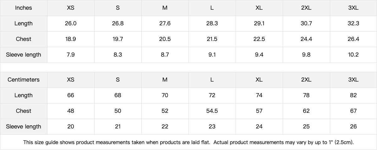
Slim fit through the chest and waist — if you prefer a relaxed drape or are between sizes, size up one. Wears cleanly on its own with dark trousers or worn denim, or layered under an open corduroy overshirt the way archival reproductions look best: centered, unhurried, and in context.
Fabric & care
100% compact-yarn combed cotton, 210gsm mid-weight, pre-shrunk, bio-polished, single-needle stitched neckline, ribbed cotton-poly collar, tear-away label. Heather Gray is 90% combed cotton / 10% viscose. Machine wash cold, tumble dry low, do not iron the print.
Share