The Tunnel Map
The Tunnel Map
Couldn't load pickup availability
Groundbreaking: June 19, 1961. Completion: February 6, 1967. 693,000 tons of granite removed.
Why this tee
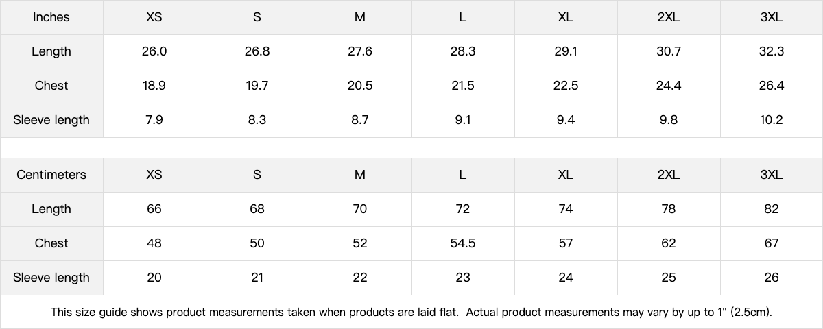
Fit: Mid-weight and slim-cut, wears like a technical brief someone handed you in a parking structure — purposeful, clean, slightly too specific to ignore.
Print: Chest-sized cartographic diagram of a subterranean network with classified-document energy — dotted routes, labeled nodes, and a few corridors that trail off the edge of the known map.
Vibe: For Cold War infrastructure readers, anyone who has pulled NORAD declassified fact sheets at 2 a.m., and the engineers who understand exactly why you'd route a tunnel with a curve instead of a straight line.
The lore
On June 19, 1961, the U.S. Army Corps of Engineers broke ground on an excavation project inside Cheyenne Mountain, Colorado. The mandate was specific: carve a hardened command-and-control facility into 9,565 feet of solid granite, capable of surviving a nuclear strike and maintaining operations for over a month with no outside contact.
By completion in 1967, 693,000 tons of granite had been removed. Fifteen freestanding buildings — 13 of them three stories tall — were constructed inside the hollowed mountain and mounted on 1,319 steel coil springs, each 3 inches in diameter, so the structures could absorb a blast without touching the rock walls. The main tunnel runs a quarter-mile into the mountain and curves deliberately, because a straight bore would have intersected gold mines in Divide, Colorado. Two 25-ton blast doors seal the complex in under 20 seconds.
That facility is real, documented, and on a fact sheet maintained by NORAD at Peterson Space Force Base. It is a matter of public record.
The map on this tee asks a different question: if a $142.4-million granite city was built under a Colorado mountain in 1961 and officially disclosed in 1966, what else was routed through bedrock during the same decade — and by whom?
The dotted lines are not decorative. They are a hypothesis.
Primary source
The Cheyenne Mountain Complex groundbreaking date, construction cost, tonnage excavated, building count, spring count, and blast door specifications are documented in the official NORAD Cheyenne Mountain Complex fact sheet at norad.mil. The January 1966 public unveiling is further documented in a declassified Washington Post article held in the CIA reading room.
Sizing & styling
Slim fit through the chest and waist. If you prefer the tee to drape rather than tuck, size up one. Wears well with dark cargo trousers and clean white shoes, or tucked under a zip-front technical jacket — the kind of outfit a facility manager wears on a site tour.
Fabric & care
100% compact-yarn combed cotton, 210gsm mid-weight, pre-shrunk, bio-polished, single-needle stitched neckline, ribbed cotton-poly collar, tear-away label. Heather Gray is 90% combed cotton / 10% viscose. Machine wash cold, tumble dry low, do not iron the print.
Share